


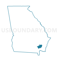
0257 - SCHLATTERVILLE Voting District, Brantley County, Georgia
About
Outline

Summary
| Unique Area Identifier | 560369 |
| Name | 0257 - SCHLATTERVILLE Voting District |
| County | Brantley County |
| State | Georgia |
| Area (square miles) | 41.33 |
| Land Area (square miles) | 40.13 |
| Water Area (square miles) | 1.21 |
| % of Land Area | 97.08 |
| % of Water Area | 2.92 |
| Latitude of the Internal Point | 31.10389750 |
| Longtitude of the Internal Point | -82.15991110 |
Maps


Graphs
Select a template below for downloading or customizing gragh for 0257 - SCHLATTERVILLE Voting District, Brantley County, Georgia


Neighbors
Neighoring Voting District (by Name) Neighboring Voting District on the Map
- 0256 - HOBOKEN Voting District, Brantley County, GA
- 0258 - CALVARY Voting District, Brantley County, GA
- 0495R - RACEPOND Voting District, Charlton County, GA
- 299400 - 1231-151 Voting District, Ware County, GA
Top 10 Neighboring County Subdivision (by Population) Neighboring County Subdivision on the Map
- Waycross CCD, Ware County, GA (26,202)
- Folkston CCD, Charlton County, GA (9,330)
- Hoboken CCD, Brantley County, GA (5,355)
Top 10 Neighboring Unified School District (by Population) Neighboring Unified School District on the Map
- Ware County School District, GA (36,312)
- Brantley County School District, GA (18,411)
- Charlton County School District, GA (12,171)
Top 10 Neighboring State Legislative District Lower Chamber (by Population) Neighboring State Legislative District Lower Chamber on the Map
Top 10 Neighboring State Legislative District Upper Chamber (by Population) Neighboring State Legislative District Upper Chamber on the Map
Top 10 Neighboring 111th Congressional District (by Population) Neighboring 111th Congressional District on the Map
Top 10 Neighboring Census Tract (by Population) Neighboring Census Tract on the Map
- Census Tract 101, Charlton County, GA (9,330)
- Census Tract 9603, Brantley County, GA (5,355)
- Census Tract 9509, Ware County, GA (4,008)